What you can see on the Guardamar webcams
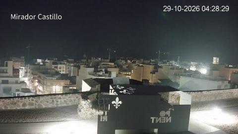
The camera is on the castle hill, the highest point of the old town, and looks east over the rooftops to the sea. In front are the castle's stone walls; below spreads the grid of white houses and apartment blocks, with a church tower on the right and a band of deep blue Mediterranean right across the horizon. The dark green line on the left is the edge of the pine woods that cover the dunes. It shows the weather over the coast and the colour of the sea, rather than the beach itself.
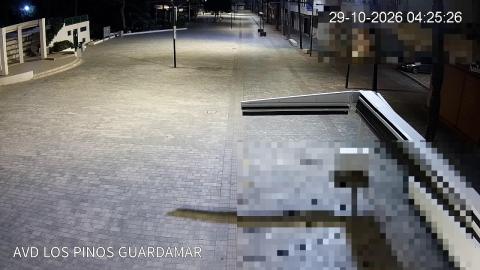
A second camera, also run by the town council, looks along the Avenida de los Pinos, a wide pedestrian avenue with café terraces, and shows the life of the town at street level.
Guardamar, its pine woods and the sea from the castle
Guardamar's town council streams this view from the viewpoint on the castle hill, where the medieval town stood until the earthquake of 1829. In the foreground are the castle's old stone walls and a white metal panel with cut-out lettering; below spreads the new town, built after the earthquake, in a tight grid of flat roofs, white houses and apartment blocks, with building cranes here and there and a church tower with a red-tiled dome on the right.
The camera faces east, and the whole horizon is Mediterranean. On the left, the dark green band behind the houses is the edge of the pine forest planted on the dunes. In the afternoon, with the sun behind the camera, the sea turns a deep blue; it is the view for checking the sky and the sea before heading down to the beach.
Guardamar webcam: Avenida de los Pinos, live
The town council's second camera looks along the Avenida de los Pinos, a wide pedestrian avenue paved in grey setts, from a low rooftop at one side. The street runs straight away from the camera between palms and low buildings, with café terraces and sunshades further down and a pergola and steps on the left. The lower right corner of the picture, and a block at the top right, are blurred to protect the privacy of the homes beside the camera.
It does not show the beach: it is the view of the town itself, for how bright or wet the streets are and how busy it is, from quiet weekday mornings to the summer evenings when the terraces fill up.
A town rebuilt after an earthquake
Until 1829 Guardamar stood inside the castle walls. That year an earthquake destroyed the medieval town, and a new one was laid out on the plain below with straight streets running north to south and low houses with wide patios, designed to stand up better to the next tremor; that is the grid you see from the camera. Then the sand became the problem: at the end of the 19th century the dunes began to bury the north of the town, and from the end of the 1890s the forestry engineer Francisco Mira planted them with pines, palms and other trees. The result is a forest of about 800 hectares (2,000 acres) that now runs behind the beaches. Older history lies in it too: the remains of a Phoenician trading post and of a 10th-century Islamic religious retreat have been excavated in the dunes.
When to watch Guardamar
The Costa Blanca is on Spanish time, one hour ahead of the UK and Ireland. The camera faces east, so in the morning it looks into the sun; the view is at its best in the afternoon, with the sun behind it and the sea a deep blue.
Around Guardamar
The Alfonso XIII and Reina Sofía parks, inside the pine woods, are a short walk from the centre. Torrevieja and its salt lagoons are about 10 miles (16 km) south, and Santa Pola and Alicante lie to the north.
Visiting Guardamar
Alicante–Elche airport is about 14 miles (23 km) to the north. The main town beaches, Centro and La Roqueta, are a few minutes' walk from the centre; the castle and its viewpoint are reached on foot up the hill.