
What you can see on the Sierra Nevada webcams
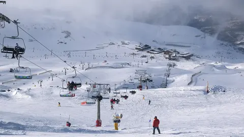
The resort's own live cameras are panoramic and turn slowly in each clip. The highest, above 3,000 m (9,840 ft) in the Veleta zone, looks over the whole ski area to the plain of Granada. At Borreguiles, halfway up, the sweep runs from the lift stations and the beginners' conveyor belts to the white dish of a radio telescope on the ridge; lower down, Montebajo covers the runs back to the village. Another camera stands by the Laguna chairlift, above an empty valley, and in Pradollano a still camera looks up the last piste over the rooftops. In winter they show snow and skiers; from late spring to autumn, dark rock and alpine grass.
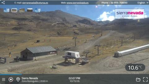
Sierra Nevada live cam at Borreguiles, 2,690 m
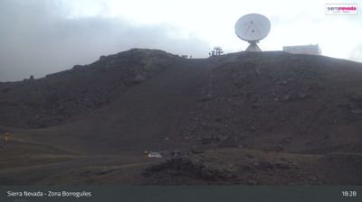
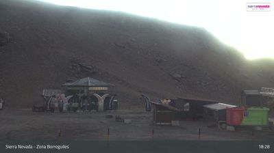
This is the resort's own panoramic camera at Borreguiles, at about 2,690 m (8,830 ft), the busy hub halfway up the mountain where the gondola from Pradollano arrives. Each clip begins on the lift stations, a long low building with a solar roof and the parked piste machines, turns across the gentle slopes laced with covered conveyor belts for the ski schools, and climbs to the ridge where the white 30-metre dish of the IRAM radio telescope stands against the sky. It ends on the beginners' area and the cafés at the foot of the slope.
In winter it shows the snow cover, the cloud on the ridge and how crowded the nursery slopes are. A 24-hour time-lapse of the same camera follows further down.
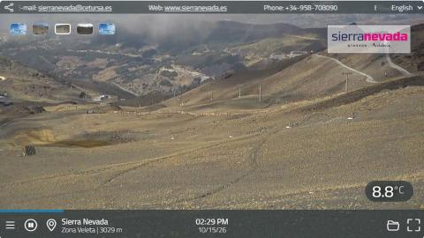
From the Veleta zone at 3,029 m, down to Granada
At about 3,029 m (9,940 ft), this is the highest camera in Sierra Nevada, in the Veleta zone at the top of the ski area. Its panorama opens with the view down over the resort: long grey slopes crossed by lift lines and tracks, the buildings of Borreguiles far below and, beyond the foothills, the plain of Granada. It then turns uphill across dark scree and boulders to the top stations of the highest lifts and a covered snow cannon.
Up here the weather is a different world from the city. The camera shows wind-scoured slopes, ice on the rocks and cloud racing over the summit. On clear days it is the best view of the whole mountain.
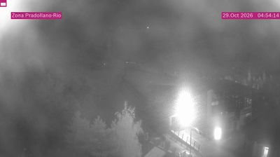
Pradollano webcam where El Río ends in the village
Sierra Nevada's own camera in Pradollano looks from above the rooftops of the village up the end of the ski area, the spot the resort calls Pradollano-Río. In front are the dark roofs and terraces of hotels and apartments; behind them the bottom of the pistes, a lift line and snow fences climb towards the bare ridge on the skyline. The picture carries its name and the date and time in pink labels.
El Río is the long run that brings skiers down from Borreguiles to the village, so this camera shows whether there is snow all the way to the bottom. It faces the midday sun, which can flood the picture; mornings and late afternoons are clearer. It is a still image, not video: the refresh button brings the latest one.
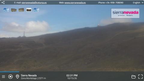
Montebajo, the slopes above Pradollano
The Montebajo camera stands at about 2,370 m (7,780 ft), on the lower half of the mountain between Borreguiles and the village. Its panorama follows a long, open ridge with the line of a run climbing it, sweeps past the top of a lift station and its metal roof, and looks down the wide slopes that lead back towards Pradollano, with lift pylons and the bend of a piste.
These are the runs that bring skiers home at the end of the day, and they are the first to lose their snow in spring, so this camera tells you whether it is possible to ski back down. In the morning it looks into the sun, and the picture can be hazy until midday.
Pradollano webcam: where the slopes reach the village
This is the resort's own camera in Pradollano, the village of hotels and apartments at about 2,100 m (6,890 ft). It looks from above the rooftops up the bottom of the ski area: a broad run with snow fences along its side, a lift line climbing the hill and the bare ridge on the skyline. Its own label calls the spot Pradollano-Río; El Río is the long run that brings skiers back down from Borreguiles.
Because it is the lowest point of the resort, this is where the snow runs out first, so it is the camera that tells you whether you can ski all the way back to the village. It faces the midday sun, which can flood the picture; mornings and late afternoons are clearer. Windy shows it as a time-lapse of the day.
Sierra Nevada webcam at Borreguiles, up to the radio telescope
Borreguiles, at about 2,700 m (8,860 ft), is the heart of the ski area: the gondolas from Pradollano arrive here and the ski schools gather here. This feratel camera does not hold one view but pans across the whole basin in each clip. It starts on the lift stations and the parked piste machines, follows the covered conveyor belts that carry beginners up the gentle slopes, climbs to the ridge where the white dish of the IRAM radio telescope stands against the sky, and ends on the children's area of the Jardín Alpino.
In winter it answers the questions that matter: how much snow there is, how busy the nursery slopes are and whether the cloud is down on the ridge. Two of its positions, the telescope slope and the Jardín Alpino, also appear further down as 24-hour time-lapses.
The Laguna chairlift and the high valleys of Sierra Nevada
The second feratel camera stands by the bottom station of the Laguna chairlift, a stone and timber building with the lift line running up the hillside behind it. From there it pans away from the resort: along a line of rocky crests and down into a wide, empty valley where a stream winds through alpine grass, a view with no buildings at all.
It is the camera to watch for the weather on the high mountain. Cloud rolling over the crests, fresh snow on the rocks or a clear sky all show up at once, and at sunset the summits glow red while the valley falls into shadow. In the ski season the slopes beneath the lift fill with skiers. Further down, a time-lapse replays the station view over the last 24 hours.
Europe's southernmost skiing
The resort climbs from Pradollano, at about 2,100 m (6,890 ft), to around 3,300 m (10,830 ft), just below the 3,398 m (11,148 ft) summit of the Veleta. Next door rises Mulhacén, at 3,479 m (11,414 ft) the highest peak in mainland Spain. In 1996 Sierra Nevada hosted the Alpine World Ski Championships. Its best-known run, El Río, drops about 3 km (2 miles) from Borreguiles to the village, and on some winter evenings it is floodlit for night skiing. The dish on the ridge is the 30-metre radio telescope of IRAM, a French, German and Spanish institute, which has been studying the sky from 2,850 m since the 1980s.
When to watch Sierra Nevada
The ski season usually runs from late November or December to April, sometimes into early May. The resort is one hour ahead of the UK and Ireland. The mountain is clearest in the morning; on spring afternoons cloud can build over the peaks. The sun is fierce at this altitude, and around midday it can shine straight into some of the cameras and wash out the picture.
Around Sierra Nevada
Granada and the Alhambra are below, on the north side of the range. On the south side lie the Alpujarras, white villages on terraced hillsides, and beyond them the Costa Tropical, so in spring it is possible to ski in the morning and reach the Mediterranean by the afternoon.
Visiting Sierra Nevada
The road up from Granada, the A-395, climbs all the way to Pradollano, and there is a daily bus from Granada's bus station. In winter, carry snow chains and check the road before setting off. The nearest airports are Granada and Málaga.